Originally published Tuesday, December 30, 2008 by New York Press
By Melissa Stern
 The current exhibition at Hebrew Union College Gallery seems particularly apt for 2008. Envisioning Maps is a giddy investigation of maps and more interestingly, the underlying concept of “mapping;” getting lost, getting found and staking out a place to belong in the world. Whether it’s a historical scarf mapping the invasion of Normandy or Paula Sher’s staggering, insanely wordy map of Israel and its neighbors, the desire to know where one is resonates loudly in a world where we don’t seem to know where we are going.
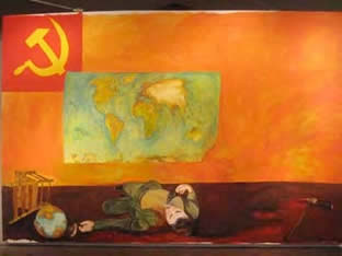
This is an exhaustive and surprisingly edgy exhibit. Thirty-three artists from a variety of backgrounds and geographies have each contributed artwork in a wide range of media. It all makes for an exhilarating and challenging show. The minute you walk in you are hit by Mike Howard’s giant (9’ x 14’) painting, “Leon Trotsky Murder Scene in Mexico City.” Boom! Curator Laura Kruger has just informed you that she intends this exhibition to examine the map as both political and personal animal. Nothing is neutral in this exhibition, and I like it like that. Many, but not all of the pieces refer to some aspect of the place of Jews in the world—a loaded subject if ever there was one. Kruger has managed to walk the line between disparate
politics, preferring to work with artists who approach the subject in a very personal and emotional way, rather than throw down an ideological gauntlet.
Karen Gunderson’s poetic portrait of the night sky takes on a deeper resonance when we read that she has recreated the constellations of Oct. 1, 1943, the night that the Jews of Denmark were due to be rounded up and deported to concentration camps. She depicts the sky looking north, towards Sweden, which is where 95% of the Danish Jews were smuggled to safety. It’s a work that succeeds at once as painting, as conceptual art and as a souvenir of history.
Imperialism, pollution and racism are addressed in various works, but always in a way that emphasizes their personal impact. Doug Beubhas studded a globe with matches; the world is literally ready to catch on fire. Paul Weisman’s woodcut of the toxic cloud that drifted from Chernobyl over Europe is at once formally beautiful and chilling. William Kentridge’s map entitled “Budapest/Soweto” connects the expulsion of one set of undesirables with the treatment of another.
One of the most chilling maps in the exhibition is “Neu-York” as envisioned by Melissa Gould. A lithograph map of New York City has been altered, painted over and renamed as if the city, having been taken over by the Germans, is now a mini-Berlin. It hits home when you try and find your home and realize that you now live on Adolph Hitler Plaatz.
Some of the most interesting works in the show are the historical novelty maps. The aforementioned scarf depicting the invasion of Normandy, “Our Way,” a board game for 1945’s immigrants to Palestine and an intricately detailed woodcut from 1581 entitled “The Entire World in a Cloverleaf” are each fascinating examples of how maps have been used by artists, politicians and visionaries to help us find our way in the world.
Through June 26, Jewish Institute of Religion Museum at Hebrew Union College, 1 W. 4th St. (at Broadway), 212-824-2205; times vary, FREE.
